

Quick Summary
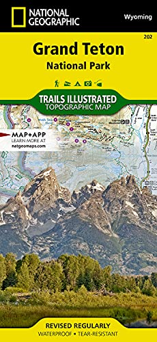
The National Geographic Trails Illustrated Grand Teton National Park Map is a topographic outdoor recreation map for the Grand Teton area. It includes hiking trails, backcountry campsites and zones, trail descriptions and a UTM grid printed on the map for GPS navigation.
The map is described as waterproof and tear-resistant, and it is regularly revised. It also covers the Grand Teton area in detail, including Grand Teton National Park and nearby recreation and wilderness areas named on the map.
Key Details
| Detail | Verified information and buyer relevance |
|---|---|
| Product type | Topographic outdoor recreation map for the Grand Teton area. |
| Brand and series | National Geographic Trails Illustrated map. This helps identify the exact map range. |
| Main area covered | Grand Teton National Park and the wider Grand Teton area. |
| Trail information | Hiking trails and trail descriptions are included for route planning. |
| Navigation aid | UTM grid is printed on the map to aid GPS navigation. |
| Backcountry information | Backcountry campsites and zones are shown on the map. |
| Revision status | Regularly revised, which is useful if current route information matters. |
| Map finish | Waterproof and tear-resistant. |
What to Compare Before Buying
- Coverage: Check that the mapped area matches the places you want to visit, including any specific parks, wilderness areas or nearby destinations.
- Navigation detail: If you plan to use GPS alongside the map, the printed UTM grid is a useful feature to look for.
- Trail information: Compare the level of trail description and backcountry detail with the kind of trip you are planning.
- Map format: This is a topographic recreation map, so it suits buyers who want route detail rather than a simple overview map.
Using It in Practice
The map is set up for outdoor trip planning in and around Grand Teton National Park. It names a number of surrounding recreation and wilderness areas, so it works as a broader planning map rather than only a single-park sheet. That makes it useful when you want to compare routes, identify trail access points and plan backcountry stops before setting out.
Before You Decide
Confirm that this map covers the exact Grand Teton area you want to visit, especially if you need a specific trail, campsite or nearby destination. If GPS support matters, check that the printed UTM grid suits the way you navigate. The map is waterproof and tear-resistant, so it is aimed at outdoor use rather than desk-only reference.